Wednesday, April 30, 2008 - Independence KS
< previous day | archives | next day >

Sunset in the Park, Elk City Reservoir - April 30, 2008
Elk City State Park campground
My black tank needs to take a dump making a night in a campground a desirable departure from my usual Wal-Mart parking lot thing and what a fine campground this is. Elk City State Park has some beautiful modern campgrounds on the east side of Elk City Reservoir and I bagged a site right at waters edge. Nice. Nice sunset over the lake to boot.
Night camp:
Site 13, Sunset Point, Elk City State Park, Independence, Kansas
Horsetail by Maggie Lake
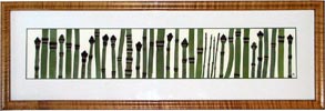
A visit yesterday to The Berkshires Art Festival got a little expensive but I just couldn't resist - a gorgeous Maggie Lake pressed flower portrait, Horsetail.