My 2006 Road Trip
This is a journal of my April 2006 road trip. I'll try to post entries as I move along and as I find internet access. These entries will be quick notes of things I want to remember and may not read too smoothly. I'll try to come back flesh them out a bit.
DAY 1 - Friday March 31, 2006 - Red Rock to Somerset PA - 485 miles
Via Co Rt 9 north to East Chatham NY then Albany Turnpike west to Nassau NY then US 20 west to I-90 west to I-88 west to Binghamton NY then NY 17 west to US 220 south to I-80 west to US 219 south to Somerset PA.
Albany Turnpike to Nassau NY
Depart 10:15 AM. Oh darn this ain't gonna be fun; my air conditioner doesn't seem to be working. This promises to be a 70 degree day too. A good test of the Tacoma's ventilation system is about to begin.
Thom's Cafe is in Nassau NY, once a favorite eatery but sliding down my list. Either it's losing it's edge or I'm moving on. After a late breakfast it's time to get on my way. I don't generally plan my road trips except in a very broad brush sense. This one is no different. I'm headed generally toward the southwest, with Santa Fe and Taos NM in the picture, and Henderson NV also a goal to visit cousins there.
Nassau NY to Binghamton NY
The day is warming up and I'm experimenting with window positions, fan settings etc. to see how best to get some air flow without too much wind noise. Not fun. I hadn't realized how dependent I had become on the air conditioning. The wind noise will take some getting used to.
Binghamton NY to Somerset PA
Via NY 17 west to US 220 south to I-80 west to US 219 south.
I had planned on staying on US 220 south and somehow lost it where it left I-80. When I hit US 219 I recognized my mistake and remembered taking US 219 home from Tazewell VA on my second trip to the Power-Trac factory. It was a hoot of a ride through the mountains of WV. I think I'll retrace that route and maybe have a look at Power-Trac's growing facilities. Then head west from there across southern KY.
DAY 2 - Saturday April 1, 2006 - Somerset PA to Tazewell VA - 375 miles
Via US 219 south to US 19 south.
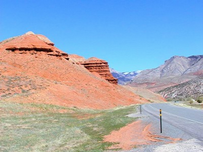
Pennsylvania wind turbine farms
Not far south of Somerset I came upon two wind turbine farms that were not there in the fall of '02 when I took US 219 home from Power-Trac in Tazewell VA (I seem to recall one tower under construction though. Impressive.
West Virginia wind turbine farm
Farther south, near the Fairfax Stone, I stopped and got some pictures of the wind turbine farm I had passed on my way north in '02 and had been so impressed with. Still impressive I must say. I've been trying to understand why folks are so against the proposed wind turbine farm in Florida MA. These things are a contemporary industrial work of art - huge, graceful on the skyline. The only impact I can see that people might object to is the noise of the wind fuffing and fluffing around the structure. It sounds a bit like riding in a car with the window open, but gentler for it's distance from the ear. Not too distracting but ever there in the background and problably can be heard for 3-5 miles or so.

Tazewell VA
I stayed once again at the Fincastle Motor Inn in Tazewell VA, a small quiet motel. Nice. I tried to figure out a way to connect to the internet via my ISP, cisbec.net. No go, I couldn't figure out how to make a long distance call with my CC. I've forgotten how. And I had not downloaded cisbec.net's VA local numbers. Wow, am I ever dependent on this technology!
For day 3 I've been wavering between blasting south to I-40 and across toward Albuquerque NM or taking old KY 80 across KY. I've decided on the latter. There are severe storms in the forecast for the Mississippi valley and it might be best to travel a bit slowly tomorrow.
DAY 3 - Sunday April 2, 2006 - Tazewell VA to Russellville KY - 456 miles
Via VA US 460 west to KY 80 west.
This route took me through Appalachian KY. Amazing country. I went through some coal fields where they are strip mining by taking off the tops of the hills. The towns and cities are amazing. The land is very steep with lots of long narrow valleys (hollers) so the roads (expensive beautiful roads) are blasted into one side of the valley and the buildings of the city are located on any flat piece of ground to be found or made, and stretch for miles in all directions, often completely disconnected from their neighbors by a stretch of mountain. A house here, a Wal-Mart there, then a post office, maybe a few more houses planted in each others front yards, a factory, a Caterpillar dealer. A car dealership a hundred feet wide and a mile long. On & on & on. Then there's the flattened mountaintop coal strip mine with the HUGE shopping mall on top and more mining going on right behind the buildings (Hazard KY if memory serves). Very interesting country.
Later in the day I luckily dodged some ferocious thunderstorms and tornadoes in western KY and TN.
UPDATE: After I holed up in the Best Western for the night, TV showed me that the next town forward of me had been whacked about 5PM. I had taken a wrong turn and by the time I got back on track, I ended up stopping for the night at a town just short of there. If I hadn't taken that wrong turn I might have been right in the middle of the action at 5PM. Then there was a second round of tornados about 10PM that really got my attention as I watched it unfold on local TV. Their interactive weather maps were astonishing in their detail. The weather commentators had a real time radar plot of the storms showing the track, speed, cell formation, flashes of lightning, hail reports and could zoom in and out and pan and were following the development and movement of cells all over southwestern KY and northwestern TN and were plotting arrival times downwind to the minute. Amazing. I'll bet they saved hundreds of lives that night. The nearest cell went about 20 miles south of me and as I watched it progress on TV I could hear the thundering outside. Cool.
DAY 4 - Monday April 3, 2006 - Russellville KY to Tulsa OK - 595 miles
Via US 68 to the Mississippi, then US 60 across MO to I-44 west to Tulsa OK.
Here I am at the end of a 600 miler in another, for me, expensive motel. I had planned to camp for as much of this trip as possible to save some money. I passed up a KOA at the 500 mile mark that was right smack dab in the middle of truck stop city. It might be tolerable in an RV but tents don't attenuate noise so well I fear. Oh well, it's only money (I did get the first $.50 coffee I've had in a long while at Lazy Lee's turnpike gas emporium). Came out of the motel this AM to find a flat tire and couldn't get the dammed wheel off. AARP tried three contractors - all booked up for at least 2 hours. Grumble. The nice Gita Patel, motel manager, called a mechanic down the road. He made two trips to the truck in his little Toyota beater, put the spare on, then at his service station fixed the flat, took the spare off, checked the other tires for pressure and handed me a bill for $16.00. Gotta love it. Things are different once you get away from civilization. There's a LOT going on out here that gets stifled in our narrow corner of the world by officialdom getting in the way of the entrepreneurial spirit.
DAY 5 - Tuesday April 4, 2006 - Tulsa OK to Dalhart TX - 471 miles
Via I-44 west to Oklahoma City then I-40 west to McLean TX then TX 273 west to Dumas TX then US 60 west to White Deer TX then TX 294 north to Skellytown TX then TX 152 west to Dumas TX then US 87 west to Dalhart TX.
This was a bit of a boring ride until I reached a nice new rest area east of McClean TX. The grounds overlook the second largest canyon in the US and has a wind power exhibit in the lobby describing the importance of windmills to the development of the area. They were and are used to pump water for stock watering. They were introduced to TX by the rancher who owned a great part of the canyon. He also played a major role in saving the buffalo from extinction by capturing some of the remaining animals and turning them out in the safety of the canyon.
Back to wind energy, the exhibit describes a new wind turbine farm just outside White Deer TX. This set me on a new course to go have a look. Quite impressive it is but more in scale to the big TX country than those in WV. Here, though there are more of them, they don't dominate the neighborhood so much. These seem to be the same size as those in WV. Data from the rest area exhibit indicates they have 180 ft dia blades on a 220 ft tower, producing 1 megawatt at 21 rpm.
DAY 6 - Wednesday April 5, 2006 - Dalhart TX to Taos NM - 473 miles
Via US 64 west to Clayton NM then US 56 west to Springer NM then NM 21 west to Cimarron NM then US 64 west to Eagle Nest NM then NM 38 west to Questa NM then NM 68 south through Taos NM to Espanola NM then US 84 north through Abiquiu NM to Tierra Amarilla NM then US 64 east to Taos NM.
US 56 between Clayton NM and Springer NM is across beautiful rolling prairie with long vistas . Big sky. Not prosperous but beautiful country. From Springer west through Miami to Cimarron is in more rolling country with a view to the mountains in the west. Economically very poor country.
Via this circuitous route I was looking for a campground to serve as a local base for a couple of days. It wasn't to be. There a few factors in play here. It's too early in the season to find many campgrounds open. Those that are open cater mostly to RV's and are really not suitable for tenting. Some don't even offer tent sites. Wilderness sites are, with a few exceptions, not open yet. And just as well as it turned into a very windy day with lots of thunderstorms moving through, and ended with snow and hail in Taos. Not my idea of fun camping. In all my travels for the day I only found two potential campsites. The first is a really nice little National Forest campground on NM 38 near Red River. I probably would have stayed but it was mid morning when I went through and I wasn't ready to pack it in for the day.
I took NM 68 south through Taos in hopes of finding a little local park and campground along the Rio Grande gorge I had stayed at years ago on a bike trip through the area. I couldn't find it. This whole area has changed dramatically in recent years. Growth has been phenomenal and there isn't much here that looks familiar to me. After looking around Espanola NM for the campground shown in my AAA Road Atlas I went north on US 84 to Abiquiu NM to see if I could find the campground shown to be there. I found it at the US Corp of Engineers park at Abiquiu Lake. A nice primitive campground but by this time in mid afternoon it was way too windy to set up a tent. So off north I go toward Tierra Amarilla hoping to find a campground in the forest. Nope. Thence I head back to Taos on US 64 east over a very high pass through the Carson National Forest. Nice road. Booming thunderstorms in all directions. Heavy snow storm at the top. Cold. Great fun.
DAY 7 - Thursday April 6, 2006 - Taos NM to Taos NM - 247 miles
Via NM 518 south to Las Vegas NM then I-25 south to Santa Fe NM then US 64 north to Taos NM.
I had set off this morning with the intention of looking around Santa Fe and Albuquerque a bit and then heading generally westward but soon enough realized I really wanted to stay in Taos for a few days to get better acquainted with the city and to unwind a bit from the long travel days. So I returned to Taos NM. Last night's motel was a bit run down and I was concerned about getting a decent room at a reasonable rate. I ended up stopping at the Indian Hills Inn which was advertising a $119.00 special for 3 nights. I was a little skeptical having paid $39.00 for a poor room the night before but this place is ok. I upgraded to $129.00 to a ground floor room with a gas fireplace. Aside from difficult to regulate sink and shower faucets, the room was fine.
DAY 8 - Friday April 7, 2006 - Taos NM - 0 miles
A day of rest and a couple of long walks around Taos.
DAY 9 - Saturday April 8, 2006 - Taos NM to Taos NM - 92 miles
Via NM 68 south to Pilar then NM 587 north through the Rio Grande gorge to Carson NM then US 285 north to US 64 east to Taos NM.
This was a quiet day in the desert, away from the busyness of Taos. I took a 2.5 mile hike along the gorge. It was refreshing to be among the birds and animals for a while. And a beautiful warm sunny day too. The kind of day that makes you glad to be alive. Tomorrow I leave for Henderson NV and my cousins' place for a visit.
DAY 10 - Sunday April 9, 2006 - Taos NM to Henderson NV - 691 miles
Via NM 68 south, US 84 south and US 285 south to Santa Fe NM then I-25 south to Albuquerque NM then I-40 west to Kingman AZ and finally US 93 west over Hoover Dam to Henderson NV.
My cousins suggested we meet at the Fiesta Casino just off US 93 coming into Henderson NV from Hoover Dam and they would excort me to their place from there. A good plan, it saved me the trouble of navigating Henderson at the end of a long day on the road. A long day made longer by the endless stream of trucks along the entire length of I-40, on a Sunday no less. Not a fun ride.
DAY 11 - Monday April 10, 2006 - Henderson NV - 0 miles

Spent the day recovering from yesterday's 700 miler and getting an introduction to the Cousin's Tour for Newbies of Henderson & the Las Vegas strip.
DAY 12 - Tuesday April 11, 2006 - Henderson NV - 0 miles
More of the Cousin's Tour with a visit to Ethel's Chocolate Factory and Cactus Garden and later a visit to the old Las Vegas strip with it's canopied promenade and light show.
DAY 13 - Wednesday April 12, 2006 - Henderson NV - 0 miles
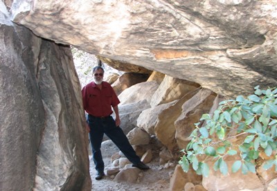
Today's Cousin's Tour took in a visit to Red Rock Canyon.
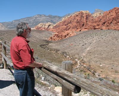
And a short hike to the waterfall.
DAY 14 - Thursday April 13, 2006 - Henderson NV - 0 miles
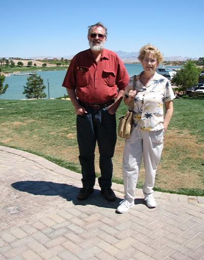
Today the Cousin's Tour took in the spactacular Lake Las Vegas resort development and a visit to Lake Mead.
DAY 15 - Friday April 14, 2006 - Henderson NV to Farmington NM - 525 miles
Via I-15 north to St George UT then UT 9 east to Mt Carmel Jct then US 89 east across the Glen Canyon Dam to Page AZ then AZ 98 to US 160 east to US 64 east to Farmington NM.
At Mt Carmel Jct it was decision time. Do I go northward around the top of Glen Canyon or southward more directly toward Taos. I chose southward.
This was a day for some spectacular scenery. The section of I-15 that nips the northwest corner of Arizona just south of St George runs along the Virgin River canyon and is amazing. My route took me across the spectacular Zion National Park as well.
DAY 16 - Saturday April 15, 2006 - Farmington NM to Taos NM - 270 miles
Via US 550 north to Durango CO then US 160 east to Pagosa Springs CO then US 84 south to Chama NM then US 64 east to Tres Piedras NM then US 285 south to NM 587 south through the Rio Grande gorge to Pilar NM and finally NM 68 north to Taos NM.
DAY 17 - Sunday April 16, 2006 - Taos NM - 0 miles
A quiet Easter Sunday in Taos.
Day 18 - Monday April 17, 2006 - Taos NM - 51 miles
Another quiet day poking around Taos. Tomorrow I head north across Colorado with Laramie WY as a tentative destination.
DAY 19 - Tuesday April 18, 2006 - Taos NM to Rawlins WY - 525 miles
Via NM 522 north to Fort Garland CO then US 160 west to Alamosa CO then CO 17 north to Poncha Springs CO then US 285 north to Buena Vista CO then US 24 north to Vail CO then I70 east to Dillon CO then CO 9 north to Kremmling CO then US 40 north and west to Craig CO then CO 13 north to WY 789 north to Creston Jct WY then I80 east to Rawlins WY.
What a day of contrasts, going from bright sunny high desert to snow in the mountains of Colorado, especially over the pass into Steamboat Springs CO, and then back to a much colder high desert. It was below freezing by the time I reached Rawlins.
In a sense Rawlins was a mistake in that I had planned to leave US 40 just before Rabbit Ears Pass and take CO 14, CO 127 and WY 230 to Laramie WY so I could check out "the gangplank" on the road to Cheyenne WY in the morning. Oh well, I guess I'll head up into central WY and see if I can get a look at the big coal trains John McFee wrote of in a New Yorker article a while back.
Here's a link to Google maps showing the coal fields south of Wright WY.
DAY 20 - Wednesday April 19, 2006 - Rawlins WY to Sheridan WY - 395 miles
Via US 287 north to Lander WY then WY 789 north to Riverton WY then US 26 north to Shoshoni WY then US 20 west to Greybull WY then US 14 east through Shell Canyon and over Granite Pass to Sheridan WY.
A beautiful cool day riding across high desert amongst snow capped mountain ranges. Wyoming is to my eye the most beautiful state in the Union. The terrain varies in its conformation and coloration with every glance; there's always something new coming into view. Rolling sagebrush desert. Varicolored rock formations. Snow capped mountains. river valleys. Green pastures.
Shell WY
The most strikingly beautiful spot I think I've ever passed through has to be Shell WY on the western approach to Shell Canyon via US 14 from Greybull WY. Shell is a verdant oasis set in the valley at the foot of Shell Canyon. A tight little valley populated with massive rounded hills of a bittersweet/coral coloration. Absolutely gorgeous. It's worth a visit if you find yourself in northern Wyoming. It's the one area I regret not photographing on this trip and I'm now thinking I might head back that way tomorrow and try to get some shots.
DAY 21 - Thursday April 20, 2006 - Sheridan WY to Buffalo WY - 229 miles
Via US 14 west back over Granite Pass through Shell Canyon and Shell WY to Greybull WY then US 16 east through Ten Sleep Canyon to Buffalo WY.
Don King Saddlery and Museum
Another beautiful cool day. I started the day with a walk around downtown Sheridan WY in search of leather shops. I struck gold in the Don King Saddlery and Museum. Don King is THE Sheridan style saddle maker. His workmanship and that of others he represents is simply incredible. I must have spent an hour and a half looking over his collection of custom and historic saddles, tack, tools, etc. And talking with a saddlemaker who was at work stamping a Sheridan style floral design on a saddle part the name of which escapes me.
Return to Shell WY
On my return to Shell WY for pictures, I stopped at the only restaurant in town for a delicious burger served at a windowside table overlooking Shell Creek. While considerably larger at population 50, Shell reminds me of Fry Canyon UT. Like the restaurant in Fry Canyon, this place also has 2 rooms to let, at $30.00 for 2 persons no less. If it hadn't been so early in my day I'd have stayed the night.
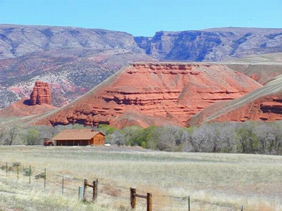
Yes, Ethel, that's Shell Canyon in the background, and yes US 14 goes up through that canyon on its way east over Granite Pass.
On Jan 9, 2008 reader Steve writes:
John;
A minor correction for your site. The caption on one picture reads: "Yes Ethel, that's Shell Canyon in the background..." It's actually Trapper Canyon. Shell Canyon would be off the photo to the left. I grew up there. I enjoyed your well composed site.
Steve"
Thanks Steve, what a beautiful spot to grow up.
The restaurant sits within a few feet of the entrance to the canyon. When I asked the proprietor what the weather is like in Shell I got a bit of a shock. Temperatures range between 20 degrees and minus 50 degrees in the winter and as high as 120 degrees in the summer. It's hard to imagine a much wider range than that.
DAY 22 - Friday April 21, 2006 - Buffalo WY to Laramie WY - 500 miles
Via US 16 east and south to Gillette WY then WY 59 south to Douglas WY then I25 south to WY 34 south to US 30 south to Laramie WY.
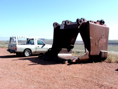
Coal
Gillette WY is situated amongst the open pit coal mines of Wyoming. I took several side roads off US 16 north of Gillette and WY 59 south of Gillette to see if I could get a look at the mines that supply about 1/3 of the steam coal in the country. I took a few pictures of the first mine I came to north of Gillette. This is one of the smaller mines, supplying only enough coal to light 3,0000,0000 homes.
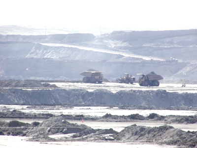
The largest open pit mine in the world
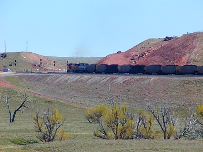
The biggy is the Black Thunder Mine southeast of Gillette. I didn't get any pictures of it. The road that bisects the mine offers some nice views but with a lot of 65 mph truck traffic and no decent pull-offs I thought it prudent not to stop for photos. It's hard to describe the immensity of the mine and equipment, the huge haul trucks racing around carrying coal to the silos and overburden to the reclamation areas. The mile long coal trains awaiting loading (I timed one train loading at the rate of about 20 seconds per car). This is big country with long views making it hard to scale the size of the operation. The viewshed is not like what we have in the east. The mine is seen as part of a big sky view of ranches, horses, the highway, antelope, rolling hills, prairie, and oil wells, etc. In the east it would dominate the view.
Somehow these big mines don't appear to be the ecological disaster they would be in the east. Most importantly I think is that the mines are located on rolling prairie land. There is no run-off into neighboring streams and rivers - there are none. The overburden stays within the pit. Only the coal is removed. The pit is sort of like the negative of a doughnut. As the mine is worked the overburden is moved from the outer edge of the doughnut to the center. As the perimeter expands, so does the center of the doughnut.
DAY 23 - Saturday April 22, 2006 - Laramie WY to North Platte NE - 412 miles
Via WY 21, the Happy Jack Road, east to Cheyenne WY then I-25 south to US 34 east to I-76 east to Julesburg CO then north to US 30 east to North Platte NE.
Ever since reading John McFee's tale of "the gangplank," a geologic anomalie giving the westward bound railroads a ramp up onto the high prairie, I've wanted to see it. The gangplank is a gradually ascending ridge running about 16 miles from Cheyenne up onto the Laramie Range of mountains to the west.
Here is a small section of the gangplank as viewed from the Happy Jack Road. Traffic on both the Union Pacific railroad and I-80 are visible along the mile or so of straight horizon at this point. There was a coal train descending when I first saw it but by the time I found a place to pull over it had passed leaving only a few trucks on I-80 to break the line.
DAY 24 - Sunday April 23, 2006 - North Platte NE to Macon MO - 533 miles
Via US 30 east to Elm Creek NE then US 183 south to Phillipsburg KS then US 36 east to Macon MO.
I'm out of the western high plains country I like so much. It's time to blast on home.
DAY 25 - Monday April 24, 2006 - Macon MO to Washington PA - 701 miles
Via US 36 east to Indianapolis IN then US 40 east to Richmond IN then I-70 east to Washington PA
US 36 is a great fast relaxing low-traffic ride across the Illinois and Indiana plains. However, US 40 east of Indianapolis is too busy and with too many towns to make decent time. I should have moved onto I-70 at Indianapolis IN.
DAY 26 - Tuesday April 25, 2006 - Washington PA to Red Rock NY - 587 miles
Via I-70 east to Youngwood PA then US 119 north to Du Bois PA then I-80 east to I-81 north to Binghamton NY then I-88 north to I-90 east to Schodack NY then US 20 east to Nassau NY then Albany Turnpike east to East Chatham NY then CR 9 south to Red Rock.
The end.
Travel by road trip has changed in the past ten years.
The growth in traffic on the major routes in the years since my last road trip is remarkable. Interstate interchanges are now often a nest of the usual national chains. Fast food, Gas, Motels, often a shopping center and Wal-Mart. What a mess. Finding a good mom-and-pop restaurant or motel is getting to be a challenge.